Beneath Montreal lies a complex arrangement of Paleozoic sedimentary rocks, notably the Trenton limestone, Utica shale, and Chazy dolostone, all overlain by Champlain Sea clays, glacial till, and intermittent sand lenses that can surpass 40 meters in thickness east of the downtown area. Determining a reliable depth-to-bedrock map via drilling alone is challenging in this setting, as conventional refusal counts often misinterpret the contact between stiff till and weathered shale. Seismic tomography circumvents this problem by directly imaging velocity contrasts, yielding a continuous cross-section instead of scattered borehole data. In the Montreal census metropolitan area, our acquisition parameters align with the NBCC 2020 site classification framework, where Vs30 is merely the starting point when distinguishing competent limestone from fractured shale with a 20-meter transition zone. This technique also reveals buried paleochannels capable of diverting groundwater toward deep excavations in neighborhoods like Ville-Marie or Griffintown.
Refusal in till is not bedrock—seismic tomography shows the velocity gradient, and the reflection stack finds the real impedance contrast beneath it.
Service characteristics in Montreal
Critical ground factors in Montreal
It is common in Montreal for geotechnical reports to assign a Site Class C or D based on a single Vs30 measurement, yet shear-wave velocity profiles from seismic tomography often show a velocity inversion—a stiff surface crust over softer clay—that markedly shifts the site period. This becomes critical for mid-rise buildings in Hochelaga-Maisonneuve or Rosemont, where the building's fundamental frequency may coincide with the site period derived from the full velocity model. Another frequent issue is confusing a line of boulders in the till with bedrock; refraction tomography alone can be inconclusive, but adding a reflection survey identifies the continuous reflector beneath the boulders. Neglecting these subtleties results in either excessive excavation costs or insufficient seismic design. The Champlain Sea clay also has a pronounced weathering crust that artificially elevates apparent velocities in the top 3–5 meters, and only an inversion that accounts for vertical velocity gradients can correct this bias in the Vs30 calculation.
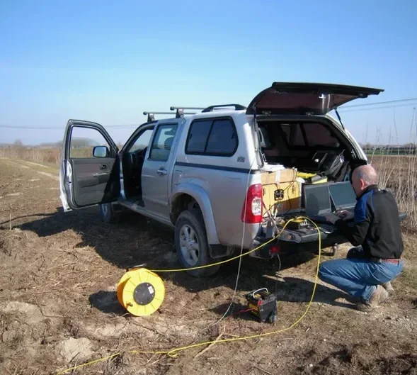
Our services
Our operations in Montreal encompass the entire seismic tomography process, from survey planning to final velocity models that are integrated with the geotechnical baseline report. Below, we outline the three primary service packages.
Refraction tomography for bedrock mapping
This package focuses on depth-to-bedrock mapping and rippability evaluation. We utilize arrays spanning up to 120 meters with 24–48 channels, processing first arrivals via non-linear inversion to capture lateral velocity gradients typical of Montreal's till-over-shale sequence. Deliverables comprise 2D velocity sections and a bedrock surface contour map referenced to site coordinates.
High-resolution reflection profiling
Refraction tomography falls short when a high-velocity cap impedes penetration or when sub-bedrock features such as faults, karst cavities in the Beekmantown dolostone, or fracture zones in the Utica shale are of interest. We employ a hammer or weight-drop source with a 48–72 channel array, applying pre-stack depth migration to generate a true-depth section with sub-meter vertical resolution.
Combined refraction + reflection with Vs30 profiling
Designed for NBCC site classification, this standard package involves both P-wave and S-wave refraction (using horizontal geophones and a shear source) to invert for Vs30. A reflection component adds a confirming bedrock reflector. The output includes a formatted site-class letter suitable for the structural engineer of record.
Top questions
What depth of investigation can seismic tomography reach in Montreal's glacial deposits?
With a 120-meter spread and a weight-drop source, refraction tomography typically achieves depths of 50–100 meters, while reflection profiling can reach 300 meters or more. The feasible limit depends on the velocity contrast at the target interface and the attenuating properties of the Champlain Sea clay, which tends to absorb frequencies above 80 Hz.
Can seismic tomography distinguish between dense till and weathered bedrock?
Indeed, this is where the method proves most valuable in Montreal. Refraction tomography reveals the velocity gradient within the till—generally 1,400–2,100 m/s—while the reflection stack captures the sharp impedance contrast at the till-bedrock interface, appearing as a distinct reflector at depth. Combining both removes the ambiguity that often misleads refusal-based borehole logs.
How much does a seismic tomography survey cost in Montreal?
For a combined refraction and reflection survey in the Montreal region, budgets typically fall between CA$3,650 and CA$6,350, depending on line length, number of spreads, source type, and whether Vs30 profiling is included. A site-specific estimate is provided after considering the project location and target depth requirements.
What surface conditions limit seismic tomography in Montreal?
Asphalt and concrete surfaces couple well with geophones using plaster or wax; loose gravel or snow cover requires burial of the sensors. The main limitation in Montreal's dense urban neighborhoods is ambient noise from traffic and LRT lines—we mitigate this with vertical stacking and by scheduling acquisition during low-noise windows, typically early morning or late evening. More info.